


 Tech
Tech
Kurumbalakotta Hills, Wayanad: Trekking, Sunrise Views and Travel Guide
Visiting Kurumbalakotta Mala in Wayanad? Find entry fee, timings, best time to visit, weather and trekking details for this popular hilltop view point.
16 August 20266 min read
Overview
Kurumbalakotta, also called Kurumbalakotta Mala, is a hilltop view point in the Kottathara panchayath of Vythiri taluk, Wayanad district, Kerala. Perched at roughly 3,251 feet (991 metres) above sea level, it is known for its 360-degree panorama of the Wayanad valley and the surrounding peaks. The short trek to the top and the sunrise views have made it one of the more popular hill destinations in the district in recent years, drawing both local trekkers and visitors from outside Kerala.
History and Legend
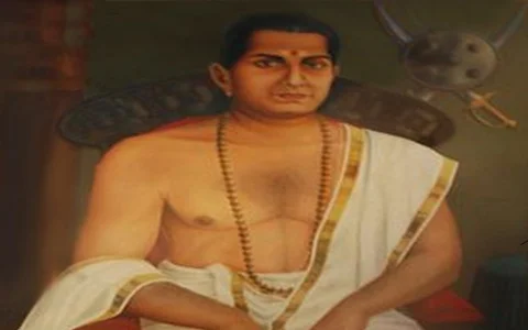
Kurumbalakotta takes its name from a fort, or kota, that once stood on the hill, although no physical remains of any structure survive today. Local legend connects the site to the period of conflict between Pazhassi Raja and the British, when Pazhassi's forces are said to have moved through this area. Another account attributes the fort to a caretaker from the Kurumba community, said to have been built to keep watch over the surrounding land on behalf of a local ruler. While the hill and the wider region were historically associated with the Vedar community, the fort itself has not been archaeologically verified, and its history remains part of local oral tradition rather than documented record.
The fort mentioned in local legend has no surviving remains. Its history is based on oral tradition rather than verified historical records.
Geography and Views
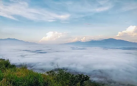
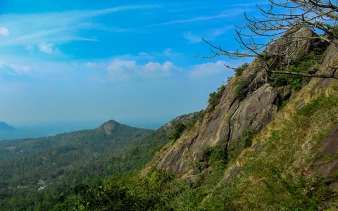
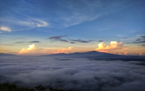
Kurumbalakotta is a monolithic hillock and forms part of the Deccan plateau, situated close to where the Western and Eastern Ghats meet. Because it sits near the geographic centre of Wayanad district, the summit offers an unusually complete view of the surrounding landscape, including peaks such as Chembra, Banasura and Ambukuthi on a clear day. The hill is best known for its sunrise views, when mist often settles over the valleys below, though sunsets from the same viewpoint are equally popular with visitors who prefer to avoid the early morning climb.
Religious Significance
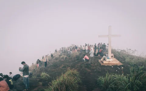
Kurumbalakotta also holds religious importance for the local Christian community. Each year on Puthiyanjayar, the Sunday following Easter that commemorates the appearance of the risen Christ to the disciples including St. Thomas, a Way of the Cross procession and Holy Qurbana are held on the hill. The procession begins at St. Sebastian's Church in Vilambukandam and concludes at a cross, known locally as the Kurumbalakotta Kurishadi, near the summit. Devotees from across Wayanad take part in the procession each year.
The Kurumbalakotta Kurishadi is private property belonging to St. Sebastian's Church, Vilambukandam. Visitors are asked not to stand on the cross or altar, or to photograph it in a way that disregards its religious significance.
Growth as a Tourist Destination
Kurumbalakotta has been drawing visitors as a trekking destination since around 2015, initially among travellers from within Kerala. By 2018, its popularity had spread to tourists from other states and abroad, and the resulting rise in footfall outpaced the hill's infrastructure at the time, contributing to parking shortages and environmental strain on the trail and surrounding land. Since then, private resorts and tent stay operators in the area have added parking, basic amenities and overnight stays, easing some of the earlier pressure. Kurumbalakotta is now regarded as one of the better known viewpoints in Wayanad, though it remains a comparatively low-key destination compared to more developed hill stations in the district.
- 2015: Kurumbalakotta begins attracting trekkers, mostly from within Kerala
- 2018: Wider recognition brings visitors from other states and countries
- 2018 onward: Private resorts and tent stays add parking and basic facilities
Trekking, Timings and Weather
The trek to the top covers roughly 1 to 2.5 km depending on the entry point used, typically taking 30 to 45 minutes at a comfortable pace over a mostly unpaved, rocky trail. There are no fixed opening or closing hours, though most trekkers start out around 5:00 to 6:00 AM to reach the summit in time for sunrise, since the trail is unlit and best avoided after dark.
Sunrise trek: around 5:00 AM to 6:00 AM start
Hill generally accessible through daylight hours
Best months to visit: September to March, when the weather is cooler and skies are clearer
Weather
Being a hill viewpoint, Kurumbalakotta stays noticeably cooler than the plains, with misty mornings especially common between September and March, which is also when visibility for the panoramic views tends to be best. Summers, April and May, are warmer but still milder than lowland Wayanad. The monsoon months bring heavy rainfall, dense cloud cover and a higher risk of landslides, which can make both the trek and the drive up unsafe, and light woollens are advisable for early morning treks even outside the coldest months.
Trekking and overnight stays are not advisable during the monsoon season, June to September, when trails become slippery and the region is prone to landslides.
Entry Fee, Parking and Trekking Tips
Entry Fee
There is no entry fee to visit Kurumbalakotta. Tent stays, night stays and other visitor services on the hill are run by private operators and are charged separately from any parking fee.
Parking Fee
| Vehicle Type | Parking Fee |
|---|---|
| Two-wheeler | ₹10 |
| Car / Jeep / Auto | ₹30 |
Parking is managed by private landowners at the base of the hill. There is no government-run parking facility at Kurumbalakotta.
Trekking Tips
Comfortable, sturdy walking shoes are recommended, since the trail is unpaved and rocky in places. Carrying drinking water and a torch is useful for those starting before sunrise, and a walking stick can help on the steeper stretches. Food options are limited near the hill itself; restaurants with a wider variety of dishes are around 8 to 10 km away, while small shops close to the hill serve tea, coffee and basic snacks.
Wear sturdy, closed footwear rather than sandals
Carry drinking water, since there are limited food and water stops on the trail
Start early to catch the sunrise and avoid the midday heat
Avoid the hill entirely during heavy rain or landslide warnings
Image Gallery
How to Reach Wayanad
By Air
The nearest airports are Kannur International Airport, about 85 km away, and Calicut International Airport (Kozhikode), about 100 km away. Both are connected to Wayanad by taxi and bus services.
By Rail
Kozhikode Railway Station, roughly 90 km from Kurumbalakotta, is the nearest major railhead and is well connected to cities such as Delhi, Mumbai and Bengaluru as well as towns across Kerala and Tamil Nadu.
By Road
Wayanad is served by KSRTC and private buses from across Kerala, Karnataka and Tamil Nadu, and the district is easily reached by road from Kalpetta, Sulthan Bathery and Mananthavady.
Nearby Attractions
Frequently Asked Questions
What is Kurumbalakotta?
Kurumbalakotta, also known as Kurumbalakotta Mala, is a hilltop view point in the Kottathara panchayath of Wayanad district, Kerala, known for its panoramic sunrise views and a short trekking trail to the summit.
What is the entry fee for Kurumbalakotta (Kurumbalakotta Mala)?
There is no entry fee to visit Kurumbalakotta or Kurumbalakotta Mala. Visitors only pay for private parking at the base of the hill, which costs ₹10 for two-wheelers and ₹30 for cars, jeeps and autos.
What are the Kurumbalakotta view point timings?
Kurumbalakotta does not have official opening or closing hours, and the hill is generally accessible through the day. Most visitors begin the trek by 5:00 to 6:00 AM to reach the top in time for sunrise, and it is best to complete the trek before dark since the trail is unlit.
What is the best time to visit Kurumbalakotta?
The best time to visit Kurumbalakotta is between September and March, when the weather is cooler, the trails are drier and visibility for the panoramic views is at its best. The monsoon months from June to September are best avoided due to slippery trails and landslide risk.
What is the weather like at Kurumbalakotta view point?
Kurumbalakotta has a cooler, hill climate compared to the rest of Wayanad, with misty mornings common between September and March. Summers are mild, while the monsoon brings heavy rain and a higher risk of landslides, which can make the hill unsafe to visit.
How long is the trek to Kurumbalakotta Mala?
The trek covers roughly 1 to 2.5 km depending on the entry point used and takes about 30 to 45 minutes on a mostly unpaved, rocky trail.
Is parking available at Kurumbalakotta?
Yes, private landowners at the base of the hill offer paid parking for ₹10 for two-wheelers and ₹30 for cars, jeeps and autos. There is no government-run parking facility.
Are there resorts or restaurants near Kurumbalakotta?
A number of resorts and tent stay operators are available in the areas surrounding Kurumbalakotta, offering overnight stays and basic amenities. Dedicated restaurants are limited near the hill itself, with a wider choice of food available around 8 to 10 km away, while small shops close to the hill serve tea, coffee and snacks.
Reviews
No reviews yet!
Recent Stories
Tech Travel
En Ooru, Wayanad: Ticket Price, Timings and Booking Guide
30 September 2026 Tech
TechGPT-6 Astra: Overview, Features, Pricing and Competitor Comparison
25 September 2026 Travel
Pookode Lake, Wayanad: Timings, Entry Fee, Boating and Visitor Guide
29 August 2026 Travel
Banasura Sagar Dam, Wayanad: A Complete Travel Guide
29 August 2026 Travel